|
Prepared by Paul Speed, P.E. LT Leon Associates prepared a hydraulic model of the Iowa River using the United States Army Corps of Engineers hydraulic modeling program, HEC-RAS. The model includes the Steamboat Rock dam, downstream bridges, and land and bathymetric (underwater) survey data near the dam. The model was analyzed for multiple rainfall scenarios including high probability rainfall events (2-Year and 5-Year rainfall events) and low probability rainfall events (100-Year rainfall event). The existing conditions scenario was evaluated along with multiple scenarios that lowered the height of the existing dam incrementally including a full removal scenario. Refer to the graphic below for approximate flood elevations within the Pine Ridge Park campground. 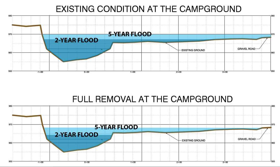 Key observations from the hydraulic analysis include:
Prepared by Maria L. Schmid, Architectural Historian 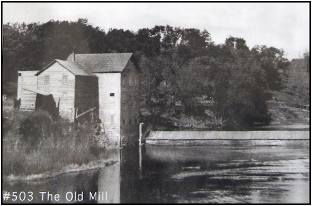 Mill and dam circa early 1900s, view from the river downstream. Source: Steamboat Rock Historical Society Archives. The dam at Steamboat Rock is an important part of the community’s history. In 1855, shortly after the town of Steamboat Rock was established, a sawmill was built on the Iowa River by Isaac Lesh, Charles Boyle, and Samuel G. Higginbotham. The sawmill produced the lumber for the businesses and homes in Steamboat Rock. In 1857, S. F. Lathorp acquired the sawmill and dam and constructed a three-story gristmill at the location. The mill had the processing capacity for 125 barrels of flour a day. The original dam was built of wood planks with rock rubble placed beneath as a structural stabilizer. The mill and the dam went through changes and repairs over the years as grain production increased. A mill house was located west of the gristmill. A fire at the mill in November of 1910 destroyed the building and, after fifty-three years of continuous operation, the mill was closed. The original wood dam deteriorated from age and was washed away by the river. For a brief time around 1912, a plan was developed to generate electricity at the old mill’s location and a powerhouse was constructed over the mill’s stone foundation. However, the idea never took off, and the hydroelectric plant was not completed. The old dam again fell into disrepair. Following the Great Depression, federal work relief projects under the Works Progress Administration (WPA) aimed to alleviate unemployment and provide economic relief. Many dams were built on Iowa Rivers during the 1930s, in addition to parks, roads, and other infrastructure. The WPA contributed $7,800 towards completion of a new concrete dam at the location of the old structure at Steamboat Rock, and the town of Steamboat Rock provided $3,200. Fifty men worked on the project for approximately three months under the supervision of Ernest Welden of Welden Brothers, an Iowa Falls company. Fifteen men from the Civilian Conservation Corps camp in Eldora also helped to build the dam. The current dam at Steamboat Rock dates to 1941, though features remain from the 1912 powerhouse construction and the earlier 19th century mill, for example, the concrete foundation on the river’s west bank and the old gristmill’s stone foundation underneath. An earthen dike on the east bank is likely a remnant from the original structure. A shelter cabin was added in 1948 above the powerhouse foundation and the west abutment was reconstructed in 1967. The Steamboat Rock Dam site is a back-drop for development in different eras. The dam has left a mark as a testament to human use and management of the Iowa River in the town of Steamboat Rock. 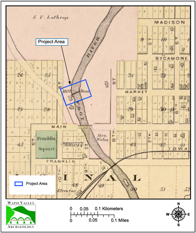 1892 Plat Map of Hardin County showing the Steamboat Rock Mill and Dam. Source: North West Publishing Co., F. Bourquin, and Balliet & Volk, Library of Congress. Prepared by Mimi Wagner and Paul Speed 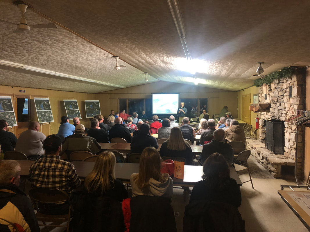 Steamboat Rock Dam Mitigation Public Meeting #2 On Tuesday evening, November 19th, a public meeting was held at the Iowa River Conservation and Improvement Club (Boat Club). Several professionals presented on various topics including, social input gathered to date, the history of the dam, the effects of the dam on fish and mussels, and the results of flood modeling work. LT Leon Associates then presented four alternatives for the Steamboat Rock Dam. You can view the presentation here.
Meeting attendees were invited to complete a survey to be turned in to the Iowa DNR. Paper copies of the survey, as well as the poster boards displaying the four alternatives, are available at the Steamboat Rock Library. The community and anyone interested in the project are invited to complete the survey. Surveys will be collected at the Steamboat Rock Library until December 3rd, 2019. Steamboat Rock Dam Mitigation Public Meeting #2 PowerPoint  Prepared by Mimi Wagner, Landscape Architect The “people” part of this engineering project is important to Iowa DNR River Programs and LT Leon Associates. A multi-step social science assessment is underway to better align local conditions with intended outcomes of the project. The first step in this social assessment was to learn everything we could about how people use the river & dam area near Steamboat Rock. Mimi Wagner, a landscape architect and environmental scientist working with LT Leon Associates, conducted interviews and small group meetings in July and August 2019. Mimi communicated with stakeholder groups and many individual residents in the area to form an understanding of use patterns and ideas for improving conditions for recreation related to the river. Results of Mimi’s research identified important recreation patterns that have been established since the current dam was constructed in the 1940’s. The below chart organizes the major themes that were identified. 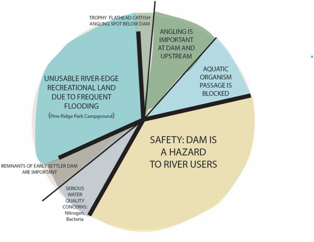 Here are a few main takeaways:
Read future blog posts to learn how these conditions were used to structure public listening at the August and November 2019 public open houses. |